
Key Insights
Luang Prabang’s UNESCO-protected core faces a modern paradox. Once a fortified capital grounded in sacred geography, its historic layout was disrupted by colonial urban planning.
Today, strict preservation rules trigger local gentrification, turning a living monastic ecosystem into a curated tourist space. At the same time, regional high-speed rail links and upstream hydropower projects threaten the peninsula’s fragile cultural and ecological equilibrium.
Axis Mundi: Latin for the “centre of the world”; a cosmic pillar or spiritual axis that connects heaven, earth, and the subterranean realms in mythology and geography.
Dok Soi: An intricate, filigreed metal roof cresting placed atop the central ridgepole of a Lao sim, symbolising the absolute center of spiritual sovereignty.
Lan Xang: Translating to “Million Elephants,” this ancient Lao kingdom (14th to 18th centuries) established Luang Prabang as its first capital and fortified sanctuary.
Nong: The traditional Lao term for the urban wetlands, swamps, and natural pools that historically functioned as a decentralised flood-mitigation and community ecological system.
Sai Bat: The sacred, pre-dawn ritual of morning alms gathering, representing a reciprocal spiritual contract between Theravada Buddhist monks and the lay community.
Sim: The primary ordination hall of a Lao monastery (Wat), architecturally distinguished in Luang Prabang by its sweeping, low-slung, tiered rooflines.
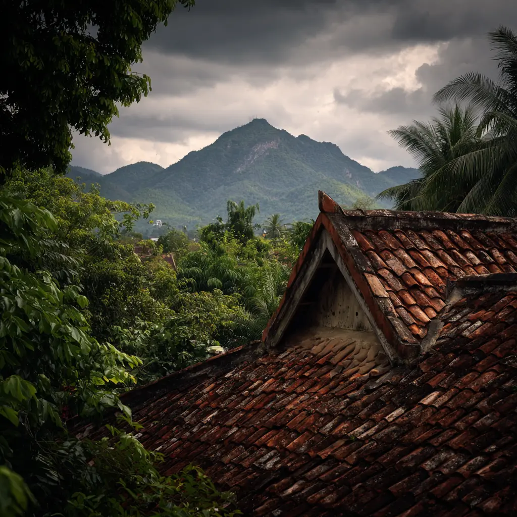
The scent of petrichor rises from the damp flagstones of Wat Xieng Thong, mingled with the faint, sweet trace of burning agarwood. Below the terrace, the Mekong River moves with a heavy, muted urgency – its swollen, clay-red waters cutting a deep path through the northern Lao limestone basin.
For centuries, this amphibious peninsula served as the fortified nexus of the Lan Xang (“Million Elephants”) Kingdom. Here, geography dictates destiny. Protected by a natural moat where the Nam Khan meets the Mekong, Luang Prabang developed not merely as a royal capital but as a living cosmic sanctuary.
Today, this ancient enclave faces a complex paradox. Decades after receiving its UNESCO World Heritage designation, the town finds itself trapped in a preservation trap, caught between the strict legal mandates of architectural conservation and the realities of modern regional geopolitics.
Beyond the romanticised travelogues of colonial villas and glittering tiered roofs lies an urban fabric navigating a profound transition. To truly understand Luang Prabang is to examine the delicate, invisible networks of monastic mobility and ecological systems that sustain its sacred geography.
The Strategic Waters and Cosmic Axis of Lan Xang
The establishment of Luang Prabang as a royal seat in the 14th century by King Fa Ngum was a masterclass in defensive and spiritual spatial planning. The historic core occupies a narrow finger of land, a landscape that offered an immediate military advantage.
Any invading force – whether Siamese, Burmese, or Black Flag bandits – had to negotiate unpredictable river currents. They also had to scale steep, unstable silt banks before mounting an assault on the royal compound. This geographic isolation allowed the town to cultivate a distinct cultural autonomy.
This physical landscape was intentionally shaped to mirror Theravada Buddhist and animist metaphysics. At the exact centre of the peninsula rises Mount Phousi. This 100-meter-high limestone outcrop functions as the town’s Axis Mundi. In local cosmology, it serves as the cosmic pillar connecting the human realm to celestial spheres.
In local belief systems, the town exists in a state of careful equilibrium. At the summit of Phousi, sacred shrines face heavenward. Meanwhile, deep within the subterranean limestone fissures beneath the peninsula, mystical forces reside. According to tradition, these spaces are where the Nagas dwell. These powerful serpent deities serve as the protectors and rulers of the local waters.
Historically, an intricate network of 183 urban wetlands, pools, and marshes known as nongs maintained this balance. Scattered across the peninsula, individual monasteries (Wats) managed these water bodies directly. The wetlands served a critical infrastructure purpose. They functioned as a decentralised flood-mitigation system during the heavy monsoonal surges of the Mekong.
Far from being stagnant pools, they functioned as communal fisheries and urban agricultural plots. This arrangement provided a resilient food supply. Consequently, the food security allowed the peninsula to endure long periods of isolation.
The Colonial Grid and the Geopolitics of Sacred Objects

The physical fabric of Luang Prabang changed permanently in the late 19th century. This shift occurred with the arrival of the French colonial administration under the Protectorat du Laos. Western observers often romanticise the town’s architectural fusion. Yet, the introduction of European urban planning was fundamentally a spatial exercise. It served as a direct tool for administrative control.
The traditional Lao urban layout was organic and decentralised, structured like a mandala where clusters of timber stilt houses orbited the protective shadow of the local Wat. The French authorities found this fluid arrangement difficult to survey, tax, and police.
In response, they imposed a rigid, rectilinear grid of brick-paved roads that physically cut through the ancient monastic grounds. This intervention reoriented the town’s primary axis away from the rivers and toward the new colonial administrative buildings, fracturing the spatial continuity of the sacred enclosures.
The Phra Bang and the Architecture of Control
Beyond the altered streets, the geopolitical history of the town is bound up with its namesake object: the Phra Bang. This 83-centimetre-tall gold-alloy Buddha statue represents the divine right to rule the Lao lands. The provenance of the icon is steeped in regional conflict. The Siamese military seized it as a political trophy during invasions in 1778 and 1828.
They carried it away to Bangkok as an explicit symbol of Lao subjugation. Its eventual return and permanent installation on the grounds of the former Royal Palace underscore its enduring role. It remains a focal point of national identity.
The Royal Palace itself, which French architects constructed in 1904 for King Sisavang Vong, embodies this complex political history. The structure employs a deliberate architectural syncretism: traditional Lao multi-tiered roofs crown neoclassical European arches and French cruciform layouts.
This grand design was a calculated effort to legitimise a puppet monarchy while French administrators quietly managed the territory’s resources. Following the abolition of the monarchy by the Pathet Lao in 1975, the palace was transformed into the National Museum.
The state preserves the royal apartments precisely as the old regime left them on its final day, presenting the past as a closed, historicized chapter within the narrative of the modern republic.
Heritage Highlight: The Dok Soi and the Architecture of Devotion
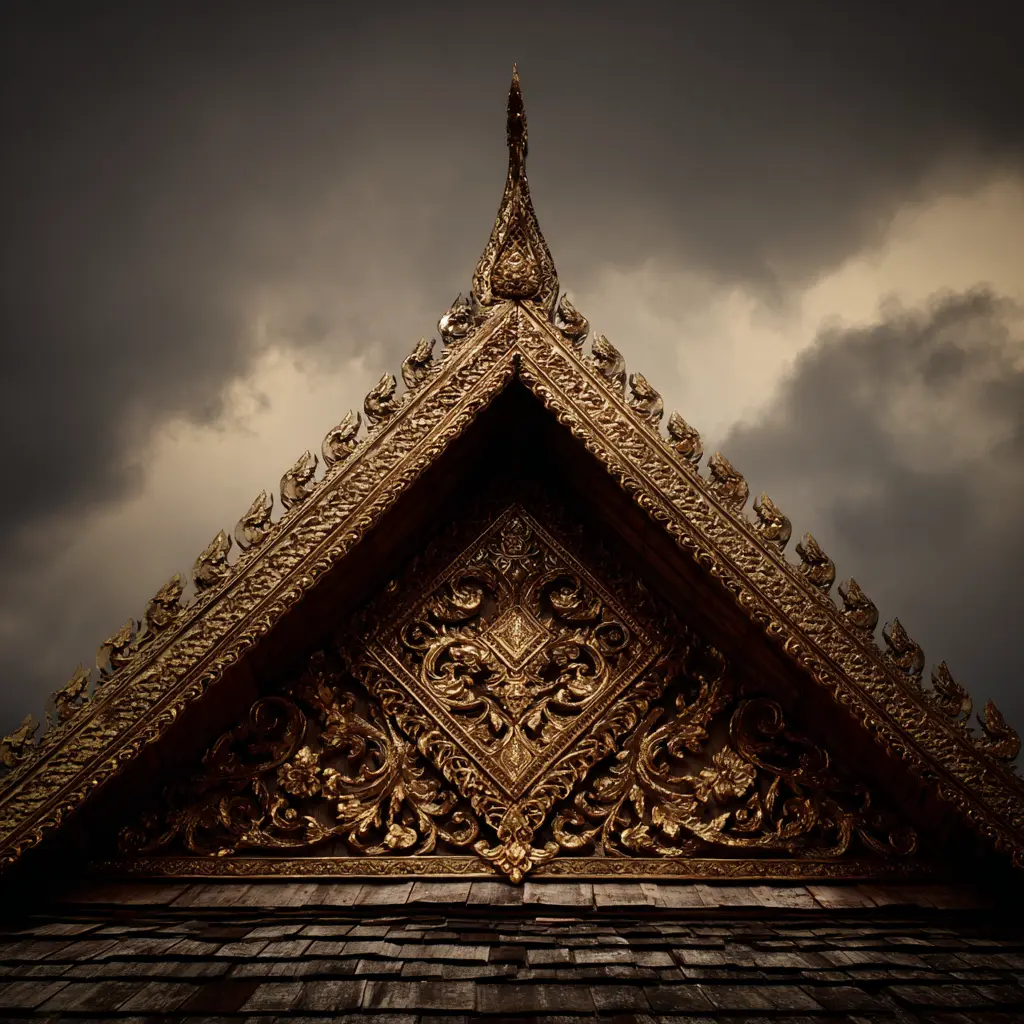
The defining architectural detail of the Luang Prabang sim is the dok soi. This intricate, filigreed metal cresting sits directly atop the centre of the roof’s main ridgepole. Executed in hammered bronze or copper, it is covered in gold leaf. The dok soi consists of small, stylised pyramidal structures. These elegant pieces closely resemble miniature pagodas or flames.
The defining architectural detail of the Luang Prabang sim is the dok soi. This intricate, filigreed metal cresting sits directly atop the centre of the roof’s main ridgepole. Executed in hammered bronze or copper, it is covered in gold leaf. The dok soi consists of small, stylised pyramidal structures. These elegant pieces closely resemble miniature pagodas or flames.
This feature serves a vital spiritual purpose. In Lao architectural theory, the dok soi crowns the building, designating the space beneath it as the absolute centre of spiritual energy.
The number of miniature spires within a dok soi is strictly regulated by tradition. Historically, these spires reflected the royal status or spiritual hierarchy of the foundation. Visually, the element breaks the long horizontal line of the roof. It draws the eye upward toward the sky. This transforms a massive timber structure into an expression of weightless devotion.
The Intangible Ecosystem: Monastic Mobility and the Performance of Merit
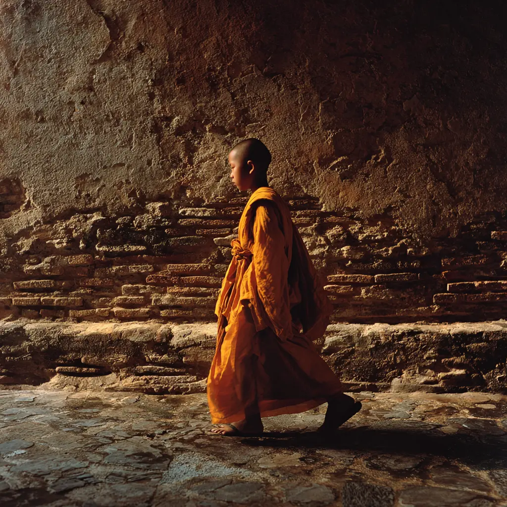
The visual appeal of Luang Prabang is deeply tied to its intangible traditions. Most notably, this includes the Sai Bat, or the ritual morning alms gathering. At dawn, a long silent line of saffron-robed monks emerges from the mist-shrouded monasteries.
They walk the streets to collect daily sustenance from the community. This ancient practice represents a reciprocal spiritual contract. The laity provides physical nourishment to the monastic community. In return, the lay devotees receive spiritual merit.
However, the rise of mass tourism has introduced commercial pressures into this daily ritual. In many quarters of the historic centre, the metabolic loop of the Sai Bat has been altered. The quiet, reflective interaction between residents and the monastic community is frequently disrupted by heavy tourist presence and commercial photography.
Unlicensed street vendors sell low-quality, stale rice to visitors eager to participate in the ritual for photographs. This dynamic creates an ethical and physical challenge for the monks.
Consuming poorly prepared food poses serious health risks. Consequently, these risks force many to quietly discard the offerings after passing the tourist crowds. This necessary action ultimately disrupts the intended spirit of the practice.
Educational Sanctuaries and Social Mobility
Behind the public performance of the ritual lies the vital social function of the Sangha (the monastic community). The young novice monks who populate the town’s monasteries are key to the region’s broader social fabric. The majority of these novices are from poor Khmu, Hmong, or Yao families living in isolated mountain villages across northern Laos.
For these families, entering a monastery in Luang Prabang offers a rare opportunity for social mobility. The Wats function as educational sanctuaries, providing free housing, meals, and access to secondary schooling and language instruction that are unavailable in rural provinces.
The daily life of the town is thus powered by an ongoing migration of youth seeking education. This movement makes the monasteries active engines of regional social development.
The Preservation Trap: Gentrification and Museumification
The granting of UNESCO World Heritage status in 1995 preserved Luang Prabang’s historic structures from demolition. However, it also initiated an unintended socio-economic shift. The strict conservation guidelines protect the town’s architectural integrity. Yet, these rules have created what urban sociologists describe as a “preservation trap.”
Under UNESCO guidelines, any modification or repair within the core heritage zone must utilise historically accurate materials. Property owners must also use traditional construction techniques. Property owners are required to use specific lime-mortar plasters, hand-fired terracotta tiles, and rare local hardwoods. For many local families, the cost of sourcing these materials and hiring specialised craftsmen is prohibitively expensive.
Consequently, a significant demographic shift occurred. Residents sold their ancestral properties to foreign investors and domestic hospitality companies for substantial sums. These traditional homes were converted into boutique hotels, upscale restaurants, and souvenir shops. Meanwhile, the original families relocated. They moved to modern concrete houses in the outer suburbs.
This process has led to a partial “museumification” of the historic peninsula. The physical facades are meticulously preserved. However, the everyday life that gave the town its vitality has largely moved outside the heritage zone.
Children no longer play on the steps of the Wats. Neighbours no longer dry river weed on the sidewalks. Family sounds have faded from the area. Consequently, the historic centre increasingly functions as a curated tourist space rather than an active residential neighbourhood.
Modern Structural Pressures: Infrastructure and Regional Connectivity
Luang Prabang’s historic isolation, which long protected its cultural landscape, has broken down in the face of major infrastructure development. The town now stands at the centre of two transformative engineering projects that present significant challenges to its heritage status.
The most immediate ecological concern is the Luang Prabang Hydropower Project, situated approximately 25 kilometres upstream on the main stem of the Mekong River. This massive 1,460-megawatt dam alters the river’s natural flow and sediment transport patterns.
Conservationists and UNESCO advisors have raised concerns regarding the project’s impact on the town’s hydrology. The dam retains the nutrient-rich silt that historically replenished the peninsula’s fragile riverbanks. This retention increases the risk of structural erosion. Consequently, the shifting ground directly threatens the foundations of historic riverside buildings.
Converting a dynamic, free-flowing river system into a managed reservoir alters the micro-climate. This environmental shift threatens seasonal river-weed harvesting. Ultimately, the loss of this resource damages local culinary traditions.
Simultaneously, the opening of the Boten–Vientiane (China-Laos) high-speed railway has fundamentally changed regional travel dynamics. Historically, reaching Luang Prabang required navigating a winding, eight-hour mountain bus journey or a multi-day river voyage, which naturally limited visitor volumes.
The high-speed rail link connects the town directly to Vientiane and Kunming, reducing travel times to a few hours. This connectivity has introduced high-velocity weekend tourism to the fragile peninsula.
The rapid influx of regional visitors places significant pressure on the town’s waste management and water supply. It also disrupts the acoustic environment. This unprecedented strain directly challenges the slow, meditative rhythm that defined the valley for generations.
The Balance of Heritage
Luang Prabang remains an important study in heritage preservation. Here, the protection of historic architecture stands in constant tension with modern development.
The value of the peninsula lies not only in its carved timber shutters or gilded roof crests. Instead, its true worth resides in less visible connections. These ties bind the landscape, the monastic communities, and the defining rivers together.
As the town adapts to new regional infrastructure and economic shifts, its long-term character will depend on its capacity to sustain these living cultural networks. This preservation ensures it remains an authentic, active community rather than a static architectural exhibit.
For those interested in the evolution of Southeast Asian urban design and preservation, exploring the contrasting history of other historic regional centres offers valuable context.
