
Key Insights
Langkawi’s history is a turbulent saga of maritime refuge, Siamese conflict, and deep-seated folklore. Once a secluded sanctuary for the Orang Laut and a strategic flashpoint for the Kedah Sultanate, the island’s soul is defined by the tragic Legend of Mahsuri.
Today, it has evolved from a “cursed” periphery into a world-class UNESCO Geopark, preserving ancient geological wonders alongside its resilient Malay heritage.
Thalassocracy: A political system defined by maritime empire rather than traditional land-based borders. In the context of the Straits, power was measured not by territory held, but by the ability to project naval dominance, enforce tolls, and secure vital shipping lanes.
Karst: A geological landscape formed from the dissolution of soluble rocks like limestone, characterised by towers, sea caves, and hidden mangroves. Langkawi’s ancient topography provided the ultimate tactical advantage, offering natural blinds, defensive strongholds, and ambushing channels for local fleets.
Orang Laut: Literally translating to “Sea People,” these indigenous maritime nomads possessed unmatched navigation skills and knowledge of regional currents. They served as the elite standing navy and privateer force for regional Malay sultanates, physically enforcing sovereignty across the archipelago.
Provenance: The documented history of an object, landscape, or culture’s true origin and ownership. Peeling back Langkawi’s modern resort branding is a quest for provenance – uncovering the raw, unvarnished historical realities that predated late-20th-century tourism engineering.
Cartographic: Relating to the art and science of mapmaking, which historically functioned as a weapon of empire. Colonial powers used cartographic manipulation to draw arbitrary borders on paper, effectively fracturing indigenous maritime alliances, disrupting traditional trade loops, and erasing regional autonomy.
To the modern traveller, Langkawi exists as a series of state-engineered commercial transactions: duty-free chocolate, jet-ski rentals along the crowded sands of Pantai Cenang, and a folklore-themed eco-resort complex. It is the definitive triumph of mass-market escapism.
But beneath this contemporary veneer of cheap alcohol and resort-brochure clichés lies a volatile, heavily contested maritime frontier. Historically, Langkawi was never an isolated paradise waiting for late-20th-century development. It was a sovereign, heavily militarised node controlling the northern entryway of the Straits of Malacca.
To understand the true provenance of the archipelago, we must peel back the modern tourism branding and analyse the physical, historical, and geopolitical structures that shaped this northern gateway.
What was the real historical role of Langkawi before it became a duty-free resort island? The answer lies in a complex matrix of deep geological permanence, indigenous naval alliances (such as the Orang Laut), colonial cartographic betrayals like the Anglo-Siamese Treaty, and post-colonial state-sponsored myth-making.
The Deep Horizon: Tectonic Architecture

To decode Langkawi, one must first look down at its immutable foundation. Long before human empires contested these waters, tectonic shifts carved out the archipelago’s geography. These massive movements made it the literal bedrock of Western Malaya.
The Machinchang Deltaic System
The towering peaks that define the northwestern spine of the main island are part of the Machinchang Formation. Dating back 550 million years to the Cambrian era, these river-borne, deltaic sandstones formed long ago.
At the time, this piece of continental crust was still attached to the supercontinent Gondwana. It is the oldest geological formation on the entire Malay Peninsula. This physical ancestor stood firm long before the mainland emerged from the sea.
The Erosional Narrative
The jagged limestone massifs of the Setul Formation in the northeast contrast sharply with ancient sandstone ridges. This dramatic topography is particularly evident around the Kilim region. Over millions of years, tropical acid rain carved these limestone structures. The process created a labyrinth of sheer karst cliffs, hidden dolines, and deep sea caves.
This is not merely a scenic backdrop; it is a slow-motion architectural collapse. The resulting topography created a highly fractured landscape of blind channels, narrow river mouths, and natural hiding spots that would later dictate the maritime military strategy of the region.
The Giant’s Scars
The island’s original animist and Malay inhabitants deeply understood this violent erosional landscape. They encoded the topography into their foundational mythology. The legendary battle between two giants, Mat Cincang and Mat Raya, permanently scarred the terrain. This story serves as an oral archive of the landscape’s jagged, shattered nature.
The story’s elements served as a functional, narrative-driven map for agrarian communities living under the mountain shadows. The “scattering of the pots and utensils” gave names to settlements like Kuah and Belanga Pecah. This anchored human geography directly to ancient geological trauma.
The Thalassocracy of the Periphery: Sovereign Hydrospace and the Orang Laut Shield
Historians cannot understand historical Langkawi through a terrestrial lens. Hydrospace defined this space – a strategic network of marine corridors, tidal channels, and maritime chokepoints where the Andaman Sea transitions into the northern mouth of the Straits of Malacca. For centuries, the island functioned as the formidable Northern Gatekeeper of the Kedah Sultanate.
The Naval Screen
The power of the Kedah thalassocracy over this outer periphery relied entirely on a calculated political alliance. The court partnered with the Orang Suku Laut. Rather than treating these nomadic sea-dwellers as primitive outcasts, the Kedah court integrated them. They became a specialised naval arm of the state’s defence infrastructure.
The Orang Laut transformed the 99 islands of the archipelago into a lethal naval screen. Operating light, highly maneuverable craft capable of navigating treacherous, shallow mudflats and mangrove estuaries where heavy European galleons or Siamese war-boats would run aground, they performed three vital functions:
The 17th-Century Pepper Pivot
This maritime security network allowed Langkawi to plug directly into global spice networks long before British intervention. In the early 1600s, the island became a major cultivation centre for black pepper, drawing French and British merchants who sought to bypass the aggressive monopolies of the Dutch East India Company (VOC) further south in Malacca.
The island’s deep-water southern bays provided safe anchorage for international spice vessels. This proves Langkawi possessed an early, highly connected cosmopolitan baseline. Modern mass tourism entirely ignores this history.
The Catastrophe of 1821: The Geopolitics of Rice and Abandonment

In November 1821, a violent force shattered the structural alliance that protected Langkawi. The Raja of Ligor orchestrated the Siamese invasion of Kedah under direct orders from Bangkok.
It was a calculated campaign of demographic and economic erasure. When the Siamese armada swept south, Langkawi was transformed from a strategic gatekeeper. It became the stage for a desperate scorched-earth tragedy.
The Strategy of Hunger: Padang Matsirat
As Siamese forces overran the mainland defences, word reached the island’s governors. The local leadership realised the Orang Laut naval screen could not hold against the massive Siamese fleet. Therefore, they executed a final, devastating directive at Padang Matsirat. This historic site is known as the Field of Burnt Rice.
The burning of the island’s central granary was a deliberate tactical decision designed to turn Langkawi into an agrarian vacuum. In 19th-century Southeast Asian warfare, invading armies relied entirely on living off the local land.
By gathering the season’s entire rice harvest, burying it in deep trenches, and setting it ablaze, the islanders ensured the Siamese would inherit nothing but a hunger trap.
To this day, heavy rains at Padang Matsirat occasionally unearth carbonised, blackened grains of rice from 1821 – a physical archive of a community choosing self-inflicted famine over capitulation.
The March of the Captives
The Siamese retaliation for this defiance was absolute. Rather than maintaining Langkawi as a productive province, the occupiers chose to ethnically and demographically dismantle it.
The Siamese forces subjected survivors of the initial massacres to the “March of the Captives.” Officers openly chained and marched thousands of islanders overland through the dense northern jungles toward Bangkok, where the state reallocated them as forced labour (corvée).
The Siamese invasion effectively emptied the archipelago of its human capital, leaving a ghostly, depopulated shadow where secondary jungle reclaimed the once-thriving rice fields for the next sixty years.
The British Silence
The bitterest layer of the 1821 catastrophe is the role played by the British East India Company. The EIC was stationed just a short sail south on Penang Island. For decades, the Sultan of Kedah had traded away territory.
He ceded Penang in 1786 and Province Wellesley in 1800. He did this under the explicit understanding that British military might would shield him from Siam.
Yet, as the smoke from Langkawi’s burning granaries rose into the northern sky, visible from Penang’s own coast, the British did nothing. Bound by mercantile priorities and a desperate desire to secure a trade treaty with Bangkok (which later materialised as the Burney Treaty of 1826), Governor Robert Fullerton chose strict non-intervention.
The EIC watched its oldest regional ally get systematically dismantled, establishing a precedent of colonial abandonment that permanently altered the geopolitics of the northern Straits.
The Outlaw Hydrospace: The Century of Fire and Salt (1821–1909)

Following the demographic scrubbing of 1821, the empty Langkawi archipelago naturally transformed into an ungoverned maritime borderland. For nearly ninety years, it was neither effectively controlled by Bangkok nor administered by the British. Instead, survival meant operating entirely outside the emerging colonial and imperial tax nets of Southeast Asia.
Rebranding the “Lanun”
Standard colonial histories and modern tourism brochures use the blanket term “piracy” to describe this era, painting these waters as a lawless nest of thieves. This is a profound misreading of provenance.
What the British labelled as Lanun activity was often something far more complex: a decentralised maritime guerrilla insurgency and an economic survival mechanism for displaced Malay and Orang Laut populations resisting Siamese hegemony.
The complex geography of islands like Pulau Dayang Bunting and Pulau Tuba offered perfect tactical sanctuaries:
The Borderland Economy
In an archipelago stripped of its rice baseline, the economy shifted entirely to high-value, low-volume maritime barter and smuggling between Southwestern Siam, Northern Malaya, and Sumatra.
This economy of pure friction thrived precisely because it was hazardous, unmapped, and untaxable. It kept the remaining population connected to global trade networks while maintaining absolute autonomy from imperial control.
The 1909 Rupture: Colonial Cartography and Preservation by Neglect
On March 10, 1909, a line drawn in Bangkok permanently bounded Langkawi’s outlaw hydrospace. The Anglo-Siamese Treaty of 1909 was a classic exercise in high-imperial border engineering. Without consulting a single local inhabitant, the British Empire and the Kingdom of Siam carved up the northern Malay states. They did this to establish a rigid modern frontier.
Slicing the Sea
The cartographers drew a line right through the water. They assigned Langkawi to the British sphere as part of Kedah. Meanwhile, neighbouring islands just a few miles north remained under Siamese sovereignty. These included Koh Tarutao and Koh Lipe.
This line shattered the historic maritime networks of the Orang Laut. Communities that had spent centuries bartering across these short stretches of water were suddenly separated by an international border, turning routine maritime migration into “smuggling” and traditional fishing into “territorial incursions.”
The Unfederated Casualties: Isolation as a Shield
Once absorbed into the British Empire, Langkawi was categorised under the Unfederated Malay States (UFMS). Unlike the Federated Malay States (FMS) further south, British oversight here was advisory and hands-off.
Because the colonial administration did not view Langkawi as a high-priority economic asset, the archipelago was entirely spared the aggressive transformations that reshaped the rest of the West Coast:
The Accidental Time Capsule
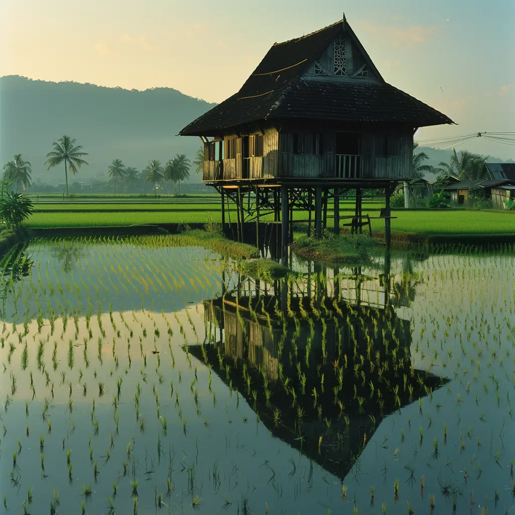
This systemic economic abandonment embedded deep, structural poverty that lasted well into the 20th century, but it also functioned as an accidental cultural shield. It allowed Langkawi to preserve its vernacular timber architecture longer than almost anywhere else on the West Coast.
Into the mid-1900s, Langkawi’s human landscape remained a network of pristine kampungs. These villages were woven into ancient wet-paddy fields. The architecture was fluid and adaptive. Timber stilt houses used local chengal and meranti wood. These structures featured elevated floors for flood protection and open layouts to maximise cross-breezes.
The monsoon winds and lunar tides dictated the rhythms of life, rather than global commodity markets, creating a landscape of pure, uncommodified provenance.
From Curse to Commodity: The Paradox of Modern Autonomy
In 1987, the accidental time capsule was deliberately dismantled. Prime Minister Mahathir Mohamad declared the archipelago a Duty-Free Zone. This profound, top-down state project changed everything. It forcefully pulled Langkawi out of agrarian isolation. Ultimately, it thrust the island directly into the global tourism economy.
This modern pivot created a bizarre paradox. To transform Langkawi into a consumption hub, the state weaponised the island’s folklore. They used historic trauma as a corporate marketing strategy. This replaced genuine historical provenance with a commercialised veneer.
The Engineering of a Myth
The cornerstone of Langkawi’s modern rebranding relies heavily on the folklore of Mahsuri, the innocent woman wrongfully executed for adultery in the late 18th century, who allegedly cursed the island with seven generations of barrenness.
From a historical perspective, the calculation behind this myth reveals a cynical marketing coup. The state framed the island’s deep structural poverty and colonial isolation as a mystical curse. This created a powerful narrative loop. This framing ignored a century of British abandonment and Siamese devastation.
The declaration of duty-free status in 1987 was framed as the literal, chronological expiration of Mahsuri’s curse. This provided a cultural “reset button.” Corporate capital carved up the coastline, transforming pristine mangrove channels and vernacular kampungs into golf courses. Luxury resorts rose under the guise of progress.
The Duty-Free Enigma
The implementation of duty-free status fundamentally altered the island’s spatial economy. Developers and state planners rapidly converted Pantai Cenang—once a quiet coastal strip defined by vernacular timber stilt houses and small-scale artisanal fishing lanes – into a chaotic, commercial strip mall.
This economy creates intellectual friction. The current tourism model invites travellers to fly to a 550-million-year-old UNESCO Geopark, only to spend their time buying imported European chocolates and cheap liquor in a concrete mall. It is a space completely divorced from its geography—the definitive hallmark of “Banalistan.”
The Landscape Audit: Seeking the True Anchor
For the intellectual traveller seeking genuine provenance on Heritasian, Langkawi’s modern surface requires a critical eye. The island’s true identity is not found in state-sponsored monuments or commercial water sports. Instead, it lives in quiet, fragile margins that have resisted commodification.
Langkawi derives its true luxury not from the artificial autonomy of a 1987 tax exemption, but from the deep, immutable architecture of its Cambrian bedrock and the resilient spirit of its maritime defenders. By stripping away the fluff, we restore it to its rightful place as a complex, sovereign frontier of Southeast Asian history.
